
Bodega Bay - Bodega Head
Maps Courtesy of California State Parks


Photos Copyright Francesca Scalpi
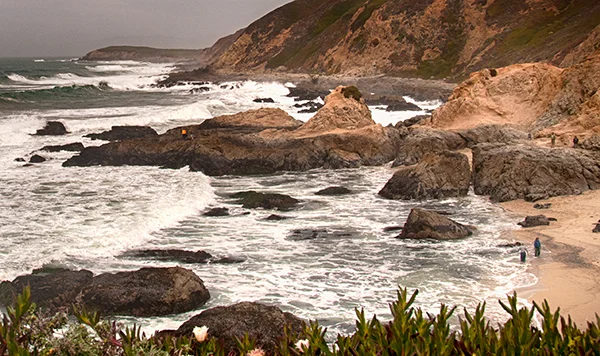
A hike on Bodega Head offers some of the most beautiful vistas in the county. On a clear day you can see a panoramic view of Bodega Bay, the Sonoma and Marin coasts, Point Reyes peninsula, Tomales Point and beyond. Bodega Head has a relatively short hiking trail that goes around the headland. This trail has spectacular views of the Pacific Ocean, Bodega Harbor, and the town of Bodega Bay. There is another trail that connects with the trail system found in the Bodega Dunes section of the park. Here you can walk along the headlands and on the beach.
Wildlife - Bodega head is a great place to see migrating whales. They can be spotted from early December through mid February when they are heading south for calving season and on their northern return trip in March and April.
1st Trail: The first trail follows the edge of the cliff going counterclockwise around the headland. Go to the south side of the parking lot and start at an unmarked path beginning to the left of the toilets. When you get to the fork, bear right, and go toward the ocean. Youll see the Fishermens Memorial which commemorates the many fishermen who failed to return home to Bodega Head. Its a grouping of cement blocks and a helm, arranged to look like the bow of a ship.
Go to the north side of the parking lot to the marked Bodega Head Trail. After passing a picnic table, youll see a side trail that goes down to a secluded beach. Once again, be careful. Californias North Coast is spectacular, but deadly. Dont walk near the surf line or climb on the rocks that jut out into the ocean. You can easily be swept away by a sleeper wave.
2nd Trail: As you go back up and continue on the path, the hike will bring you to a fork at about 3.5 miles. A trail to the left dead-ends at Horseshoe Cove Overlook, where you can see UCs Bodega Marine Lab. The trail to the right will take you to Salmon Creek Beach, a little over a mile away. Take this trail downhill until you see a sign marking the boundary of the Marine Reserve. The trail cuts to the left, and youll see a sign with the symbol of a hiker. Cut across the paved road of the Marine Lab and continue on through the dunes, following the wooden markers. The trail meets up with the Salmon Creek/Bodega Dunes loop which you can follow north to the Bodega Dunes Campground.
Veer to your left and follow the path at the edge of the bluff. At the southern tip youll get an excellent view of Tomales Point, Mt. Wittenberg and the Marin Coastline. (The Bodega Bay straddles the Sonoma-Marin County line.) Also, youll probably see and hear the sea lions which congregate at a small, nearby island to the south. To the east is Bodega Harbor and, on the other side of the harbor, youll see the town of Bodega Bay.
Wildlife - Bodega head is a great place to see migrating whales. They can be spotted from early December through mid February when they are heading south for calving season and on their northern return trip in March and April.
Take Hwy 1 to Bodega Bay. At the intersection of Eastshore Rd, you will see a sign for Bodega Head, Marinas, and Westside Park. Turn and drive down a steep hill. At the bottom, turn right onto Bay Flat Road.Drive around the harbor past Westside Park. Youll see a sign for Campbell Cove and the road takes a sharp right. Go uphill and bear right at the fork until you reach the free parking lot by the cliff.
Bodega dunes and salmon creek beach
Maps Courtesy of California State Parks
Bodega Dunes is a large state park campground and coastal dunes structure in the town of Bodega Bay. The beach here is vast and remote so beachcombers will be delighted to spend a day out here. A long walk south on the beach leads to Mussel Point and a very remote spot. Walking north on the beach leads to South Salmon Creek Beach. There are many trails through the dunes. All are open to hikers and some are open to horseback riders, but consult maps to know where you are going. The Bodega Dunes day-use parking lot is at the end of a windy paved road just inside the park entrance gate for those that don’t plan to camp. An accessible path and boardwalk leads to a viewing platform and an elevated ramp to the beach. The entrance road to Bodega Dunes is on Highway 1 just north of Bodega Bay. The beach, the dunes, and the campground are all part of Sonoma Coast State Park.
South Salmon Creek Beach is between Bodega Dunes and Salmon Creek just north of the town of Bodega Bay. To get to the parking lot for South Salmon Creek Beach, just turn west onto Bean Avenue on the south side of the bridge over the creek. At the end of the road is a parking lot in some trees just behind the dunes near the beach.
The popular North Salmon Creek Beach is across the creek which at times during the year is just a lagoon with no exit through the sand. Birds and seals sometimes congregate at the Salmon Creek spit. Walking south from the parking lot leads to a long sandy beach in front of the area known as Bodega Dunes
Sonoma Coast State Beach
Maps Courtesy of California State Parks
Sonoma Coast State Beach is actually a series of beaches separated by rock bluffs and headlands, extends 17 miles from Bodega Head to Vista Trail located 4 miles north of Jenner. Beachcombers, fishermen, sunbathers and picnickers can access the beach from more than a dozen points along coast Highway 1. The craggy coastline includes secluded coves, reefs, fertile tide pools, rugged headlands, natural rock arches, sand dunes, and wildflower-covered meadows.
Kortum Trail
(Named for the late Bill Kortum, environmentalist who fought to keep coastline access open to the public)
The Kortum Trail can be accessed at several points along the trail from the parking areas near Wright’s Beach at Peaked Hill or on the south and Blind Beach at the north end.
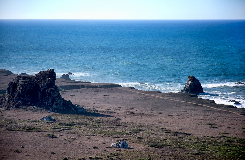
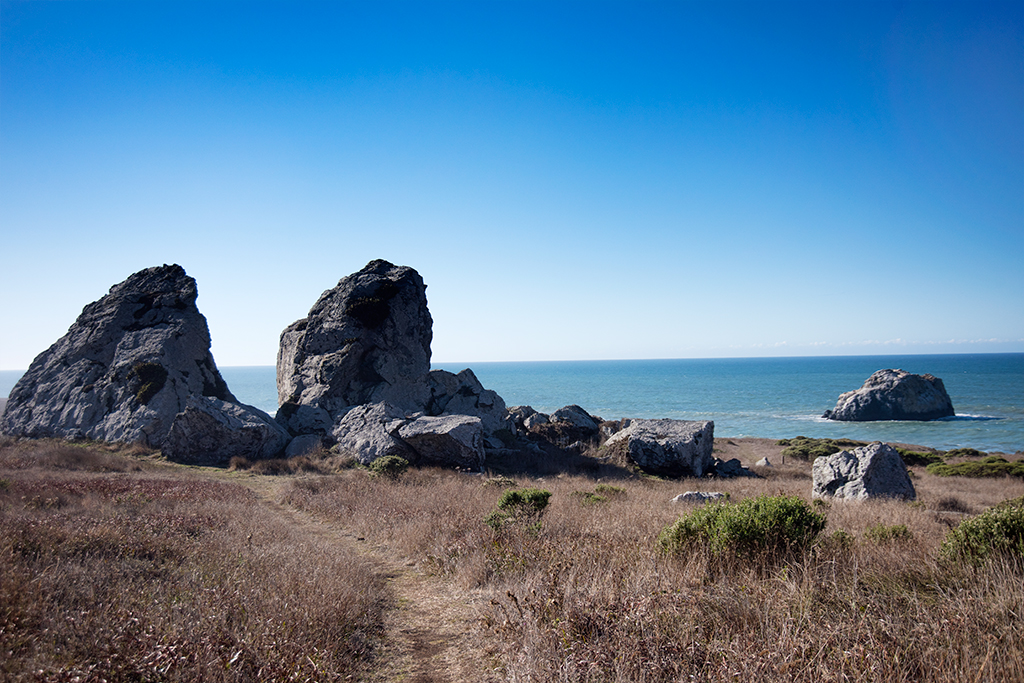
Peaked Hill (the highest point on the Kortum Trail) you can view grasslands which are the remnants of an ancient coastal prairie 15,000 years ago. There were ancient migrations of to vast migrating herds, including giant mammoths, zebra-like horses, huge sloths and bison, saber-toothed tigers, dire wolves and a California lion.
During the Ice Ages, when sea levels were dramatically lower, this prairie stretched an additional 15 miles out to sea. Today there are ancient sea stacks out in the ocean today.
Walk down from the saddle near Peaked Hill there are giant ancient sea stacks now on land. These rocks were carved by the ocean surf when the land was under the Pacific Ocean. There are large smooth patches in the rocks worn by passing ancient mammoths rubbing against the rocks.
San Andreas Fault passes runs beneath Bodega Bay and the Kortum Trail, and then follows it just offshore. The fault is a breach in the crust caused by the ongoing collision between the Pacific Plate on the west, and the North American Plate.
At the southern part of the trail is Wrights Beach. Because the beach drops off steeply with heavy wave break it creates a powerful undertow. Sleeper waves combined with riptides make this a place you need to be above the surf line.
At Duncan’s Point on Highway 1 is a Paleolithic rock shelter/sea cave known as Hipu-lana, or Coyote Hole, used by the Pomo and Coast Miwok peoples 8,500 years ago. The sea cave today is is filled with sand. Respect the site of our first Californians. It is a site protected by law so please do not disturb or take anything.
Maps Courtesy of California State Parks


Photos Copyright By Francesca Scalpi
The Kortum Trail - 4.3 mile trail between Bodega Bay and Jenner, California. This is part of a trail system that leads along the coast of Sonoma County named for Bill Kortum, a Petaluma veterinarian, who was the leader in the fight to guarantee access to the coastline for the public over developed private lands.
One of the most popular local hikes, this is an easy, flat headlands trail, 3 ¾ mile round trip for a two hour walk. Enjoy spectacular scenery along the bluffs, followed by a descent to Shell Beach. In the grasslands you might see Douglas iris, lupine, and Indian paintbrush thru April and June.
At Duncan's Point Paleolithic rock shelter, a seaside cave that was occupied for at least 8,500 years by native Pomo and Coast Miwok peoples.
CLICK HERE FOR MORE KORTUM TRAIL PHOTOS
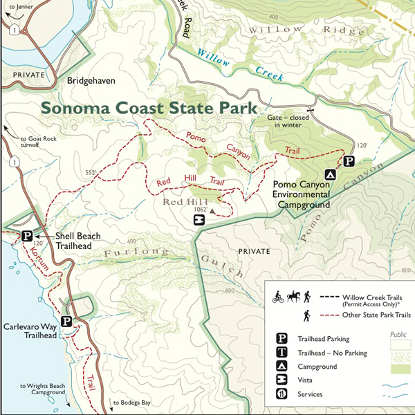
Red Hill Trail
From Shell Beach, which can be reached by either of the two hikes above or by car (located on Highway One with its own parking lot), take the Pomo Canyon Trail on the east side of the highway. The Red Hill Trail branches off the Pomo Canyon Trail and climbs through an old ranch to amazing vistas of Willow Creek and Russian River canyons, along with distant mountains and the coast.
Overview: Red Hill provides a series of trails climbing the tallest ridge just south of the Russian River on the coast. This exposed landscape of grasslands and chaparral provides plenty of sweeping vistas overlooking the mouth of the Russian River watershed out to Jenner, coastlines down to Bodega Head, and some great overlooks into Willow Creek. An old California ranch overlooking the coast and Jenner headlands.
Difficulty: Moderate
Length: 5.8 miles / 9.3 km
Duration: Half day
Family Friendly
Maps Courtesy of California State Parks
Pomo Canyon to Shell Beach
Another popular hike in this area. From Highway One near the mouth of the Russian River, you turn onto Willow Creek Road, heading east for 2.6 miles; the trail begins at the Pomo Campground. Alternatively, you can start at the western trailhead at milepost 18.22 on Highway One. This five mile roundtrip takes three to four hours and passes through redwood forest to an overlook of the Russian River and then to an overlook of the entire southern Sonoma Coast.
Willow Creek Environmental Camp. To protect the wildlife, no dogs are allowed. These sites are not on the reservation system and are first-come, first-served only. When open, Willow Creek Campground offers 11 first-come first-served primitive campsites. There are fire rings, picnic tables, and pit toilets available. All of the walk in campsites are within 1/4 mile from the parking lot and there is no running water. This is the only state park campground located near the Russian River. The sites are mostly shaded by willows and are relatively close to a large beach for swimming and fishing. Blue heron, egrets, osprey, and occasionally river otters can be seen by the river. To protect the wildlife, no dogs are allowed. These sites are not on the reservation system and are first-come, first-served only. Please only camp in the designated campsites. Camping outside of these designated campsites may result in a citation and ejection from the campground. You must self-register prior to occupying a campsite. There is no credit card payment capability. Pay fees with cash or check. Willow Creek Campground is a dry campground which means there is no water available. Please pack in/pack out all trash.
Pomo Canyon Campgrounds:
No dogs on road, trails or in campground. No group camping available. No horses. CURRENTLY OPEN as of 7/20/2021. Campsites #11 and #12 closed until further notice
Tucked into a redwood grove at the edge of the Willow Creek Watershed.Half the campsites are strung along the creek canyon, the other half dotted about the hillside, roughly along the trail leading over the ridge to Shell Beach.Pomo Canyon’s low-tech campground is perfect for minimalist camping. All gear and food has to be hauled overland from the parking lot to campsites.
Pomo Canyon Campground offers 21 first-come / first-served primitive campsites; these campsites are not on the reservation system. There are fire rings, picnic tables, and porta-potty toilets available. All of the walk-in campsites are within 1/4 mile from the parking lot. There is no running water. The campsites are shaded and located in a second growth redwood forest. To protect the wildlife, no dogs are allowed in the campground. Please camp in the designated campsites only. There is no camping allowed in the parking area. Camping outside of the designated campsites may result in a citation and ejection from the campground. You must self-register/pay prior to occupying a campsite. There is no credit card payment capability. Fees are payable using cash or personal check. Pomo Canyon Campground is a dry campground which means there is no water available. Please pack in/pack out all trash as there is no garbage service in this area.
Hiking distance: 6.6 miles round trip
3.3-mile one-way shuttle to Shell Beach
Hiking time: 3.5 hours
Configuration: out-and-back
Elevation gain: 650 feet
Difficulty: moderate
Exposure: a mix of forest and open hillsides
Maps: USGS Duncan Mills • Sonoma Coast State Beach map
To the trailhead Willow Creek Rd. • Jenner
38.430110, -123.070255
From Highway 1 and Highway 116 (just south of Jenner) cross the south side of the Russian River bridge on Highway 1. Immediately turn left (inland) on Willow Creek Road at mile marker 19.79. Drive 2.6 miles on the narrow road to the Pomo Canyon Campground turnoff. Park near the gated road (but not in front of it). The campground is open from April through November. During that time, drive a half mile up the campground road and park by the kiosk.
38.418837, -123.101977
Leave the shuttle car at the Shell Beach parking lot. The turnoff is located at mile marker 18.22 along Highway 1.

From Willow Creek Road, walk past the gate and follow the unpaved campground access road. Stroll a half mile through a grassy valley between forested hills to the campground entrance. Head into the campground on the right as the road veers off to the left. Go 15 yards and bear right on the posted Dr. David Joseph Memorial Pomo Canyon Trail.
Enter the gorgeous redwood forest and stay to the right, passing two paths on the left and the campsites on each side of the main trail. Climb up the ridge through tanbark oak, bay laurel, Douglas fir, circular stands of redwoods, sword ferns, and trillium. Emerge from the forest to a Y-fork at 0.8 miles, located in a clearing with views of Jenner and the mouth of the Russian River.
The left fork leads to the 1,062-foot summit of Red Hill and forms a loop with this trail — an optional return route.
Stay to the right towards Shell Beach, and traverse the hill. Cross a bridge over a seasonal creek and curve right, skirting a rock outcrop. Descend through brush to the open, rolling slopes with ocean views. Cross a small stream and reenter a fir and redwood forest. Cross a third stream and gradually descend through the thick brush.
Curve left into the gulch, cross the creek, and head down the draw. Ascend the hill to a knoll with a picnic area and vista point on the right. The main trail continues straight, with a view of the serpentine Russian River. Head up another hill on the wide, grassy path to a knoll atop the 500-foot oceanfront ridge and a junction with the west end of the Red Hill Trail.
Pass a trail on the right leading to Lookout Hill, then descend the slope, with views of Point Reyes, Bodega Head, Gull Rock, and Goat Rock. Drop down a partially paved utility road to the trailhead gate, across the road from the Shell Beach parking lot.
Maps Courtesy of California State Parks
Source: “Day Trips Around Sonoma County” by Robert Stone (Dayhike Books, 2016)
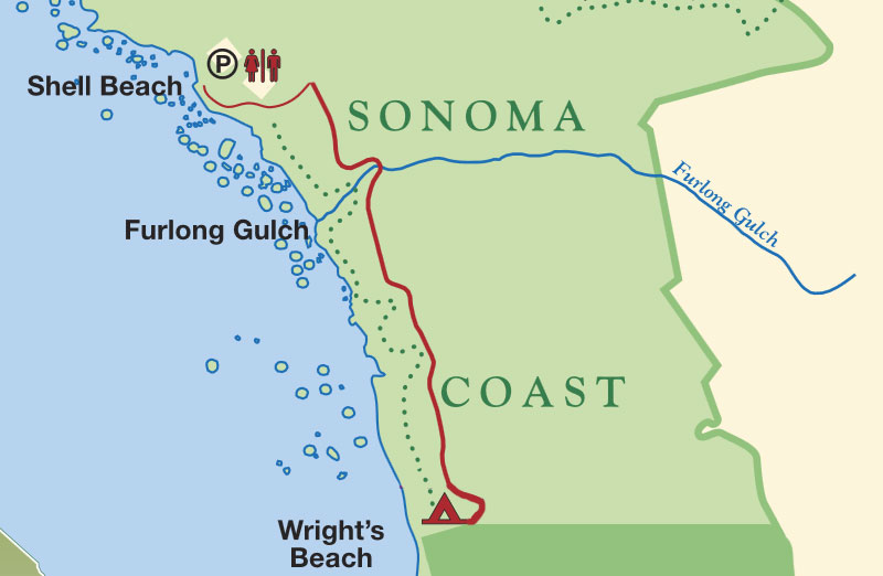
Shell Beach to Wright's Beach
Maps Courtesy of California State Parks


Photos Copyright By Francesca Scalpi
Shell beach is a scenic and geological jewel on the northern Sonoma County coast. From Shell Beach, you can hike south 2 ½ miles to Wright's Beach. You'll cross five creeks along the way; the round trip will take two to three hours. There is a campground at Wright's Beach, with a wheelchair-accessible path to the beach.
Fish head beach, Russian gulch beach and vista point trail
Maps Courtesy of California State Parks
Fish Head Beach is a narrow driftwood-covered beach about two miles north of the visitor center in Jenner, California on the Sonoma County coast.There is only room for one or two cars on the ocean side of Highway 1 at the unofficial trailhead just north of a huge hairpin corner. The narrow trail descends south along the top of a ridge to the top of a rocky outcrop. From here a steep scramble route descends left to the north end of Jenner Beach. The main trail turns right and descends to Fish Head Beach. At high tide the access to Fish Head is cut-off and dangerous to attempt. At low tide it’s possible to walk from Jenner Beach and go around large boulders to get here. If you are able to reach this beach, be watchful for sneaker waves that can crash onshore. Fishing and bonfires and prohibited at Fish Head Beach.
Russian Gulch is a pebbly beach in a deep cove where Russian Gulch Creek flows into the Pacific north of Jenner. The parking lot is just north of the Highway 1 bridge over Russian Gulch. This trail begins on the coastal side of Highway 1 and weaves through a thick riparian forest to the scenic beach cove. It has high rocky headlands towering over both sides of the cove. The creek has intermittent flows so sometimes it will flow through the sand and sometimes it will pool up and stagnate on the beach. The cove at Russian Gulch has a strong rip current so don’t swim here or you risk being swept out to sea. Russian Gulch is a stream-fed canyon that begins in the upper reaches of Little Black Mountain. The expansive sandy beach, part of the Sonoma Coast State Park, is bordered by 120-foot vertical cliffs and scattered offshore rocks.
Vista Point is a high ocean overlook along Highway 1 north of Jenner. This day-use facility marks the north end of the massive 17-mile long Sonoma Coast State Park. Unfortunately there is no beach access from Vista Point, but the view from the bluffs overlooking the Pacific Ocean are nice enough to warrant a stop. There is a picnic area here and a one-mile long hiking trail called the Vista Trail Loop. As advertised, this hike offers distant views for it’s entire length. The trail and the overlook are handicapped accessible. During the whale migration seasons (Nov-Jan and Mar-May) it is possible to see spouting gray whales from here.
Kolmer Gulch Trail - Fort Ross State Park
Photo Copyright by Francesca Scalpi
In the center of Fort Ross State Historic Park is the Fort Ross Orchard, a three-acre garden filled with apple, plum, and pear trees dating back to 1814. Across the road from the historic orchard is the Stanley Spyra Memorial Grove. The grove has the world’s oldest known second-growth coastal redwoods. The San Andreas Fault runs through the orchard and the memorial grove. During the infamous 1906 San Francisco earthquake, the ground suddenly shifted more than 12 feet. The grove has visible remnants of the earthquake, including offset creeks, sag ponds (water-filled depressions along the fault), escarpments, and damaged trees.
For a fascinating journey along the rift line of the San Andreas Fault, the Kolmer Gulch trail will show you just what a major earthquake does to the land, including the snapping of giant redwood trees and the offset of 7 ½ feet between the road and gate in 1906. Just to the east of the entrance to Ft. Ross, turn onto Ft. Ross Road and find the fire road trailhead for this hike about half a mile down the road, just past the settlers' old orchard. The trail takes you past slough trenches and sag ponds, with many wildflowers in the spring. The trail to the heavily wooded Kolmer Gulch Camp is 1 ¾ miles round trip; the full round trip is 5 ½ miles.
Fort Ross Creek Trail
Photo Copyright by Francesca Scalpi
The Ft. Ross Creek hike takes you from the parking lot down to the cove behind Ft. Ross, the site of California's first shipyard (see the interesting reconstruction in the Visitor Center). From Ft. Ross Creek at the head of the cove, follow the trail to the Ft. Ross Cemetery. From there you can cross busy Highway One, continuing onto a road that says "Authorized Vehicles Only." After a mile or so, you'll hear the sounds of Ft. Ross Creek and you'll pass a pump house and water tanks, then a cluster of cabins now serving as housing for archaeologists researching the area. The road ends here, but if you go between the last two cabins you'll find a hole in the fence and the intersection of the San Andreas Fault and Ft. Ross Creek. If you want to leave trails behind, you can descend to the creek and enjoy a remarkably beautiful hike along the creek itself, back to Ft. Ross. There are large logjams that are difficult, but possible to cross with strenuous, careful climbing.
Fort Ross State Historic Park Reef Campground & Day-Use Area
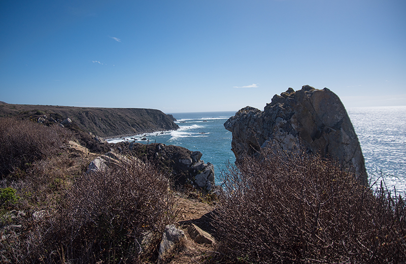
Photo Copyright by Francesca Scalpi
19005 Coast Highway 1 Jenner, CA 95450 (707) 847-3708
Enjoy diving, fishing, hiking, surfing, tide pools, picnicking, whale watching, bird watching,
or just relaxing in the sun at this secluded cove just south of historic Fort Ross.
The Day-Use Area and campground are open from April 1 to November 30. The Reef Campground has 21 primitive campsites available
first-come, first-served. No reservations are required. For more information during our off-season, call Fort Ross
State Historic Park at (707) 847-3286.
Hiking Trails: Several interesting hiking trails are available. Your camp fee and/or day-use fee allow entry to Fort Ross State Historic Park, reachable by the bluff - top trail at the campground.
Day Use:
$8.00 per vehicle
$7.00 per vehicle for seniors
$50 Bus (24 passengers or fewer)
$100 Bus (25 or more passengers)
Camping: CLOSED
Kruse Rhododendron State Natural Reserve
Trail: A up and back loop along trails that cross Chinese Gulch on wooden footbridges.
Begin the loop on the upper north side of the road. Ascend steps to the map kiosk. At the map, two post-lined paths form the short Rhododendron Loop. Begin on either path and weave through the lush forest, passing groves of redwoods and moss-covered tree trunks to the far end of the loop.
Continue straight on the north slope of Chinese Gulch through Douglas fir, tanoaks, coastal redwoods and ferns. Zigzag down to a junction in Chinese Gulch. The right fork leads 20 yards to Kruse Ranch Road at a U-shaped bend. (For a shorter loop, return 0.4 miles down the dirt road.)
Bear left and cross the wooden footbridge over the fern-lined creek. Ascend the south canyon wall and cross a small bridge. Climb two switchbacks and traverse the canyon wall, steadily gaining elevation to a junction. Bear right on the Phillips Gulch Trail, and sharply descend to Kruse Ranch Road at Phillips Gulch.
Walk 20 yards up the road to the signed trail. Descend steps and stroll through the tanoak forest. Veer right at a trail sign and pass a gorgeous hollow of redwoods. Switchbacks lead down the draw, returning to Chinese Gulch. Cross a wood bridge over the stream and wind up the hillside. Near the top, pass restrooms and continue 50 yards to Kruse Ranch Road at the trail-head.
To the trail-head 34899 Kruse Ranch Road • Cazadero - 38.593635, -123.339471
Source: “Day Trips Around Sonoma County” by Robert Stone (Dayhike Books, 2016)
The Estero Americano Coast Preserve
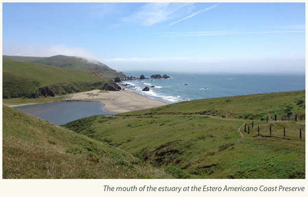
Photo Courtesy of The Wildlands Conservancy
A coastal prairie with three-quarter-mile stretch of Pacific Ocean coastline. The property includes a one-mile section along the mouth of the Estero Americano estuary. Advancing their shared missions to protect scenic, agricultural and biologically significant landscapes, Sonoma Land Trust (SLT), the Sonoma County Agricultural Preservation & Open Space District (District) and The Wildlands Conservancy (TWC) teamed up with the California Coastal Conservancy and the Gordon and Betty Moore Foundation to purchase the 547-acre Estero Ranch, located south of Bodega Bay.
We look forward to the day when this is open to public access.
Flyover Video: https://www.youtube.com/watch?v=KUERF0lKB9c
Resource Guides:
The Hiker's hip pocket Guide to Sonoma County, 3rd edition
“Day Trips Around Sonoma County” by Robert Stone (Dayhike Books, 2016)
Hiking and Adventure Guide to the Sonoma Coast and Russian River
California Coastal Access Guide
Hiking the California Coastal Trail,
Volume One: Oregon to Monterey, Second Edition